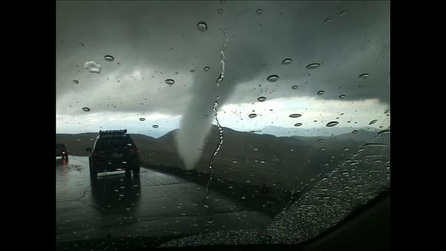
While the storm report doesn't hint at this, if the 12,500 foot elevation stands, I believe that the tornado will go down in the record books as the highest known elevation tornado in the U.S. The previous highest elevation tornado took place at Rockwell Pass, California on July 7, 2004. The elevation of the pass is 11,600 feet, and it is estimated that the base of the tornado was at approximately 12,000 feet.
If the 12,500 foot elevation of yesterday's Mt. Evans tornado stands, then it should take the record. I'm awaiting "official" comment from the National Weather Service (NWS) in Boulder, and will post that as soon as it becomes available.
***Update 7/29/12, 5pm: The NWS in Boulder has not issued a revised or updated storm report or "public information statement" on the tornado, however a recent posting on their facebook page states that they used the photographer's position and extrapolated via Google Earth that the elevation of the base of the tornado was approximately 11,900 feet. This would make it 100 feet short of the old record referenced above. So, at the moment, the Rockwell Pass tornado record stands.
I have some personal reservations about a 100 foot difference being calculated via Google Earth, but "it is what it is..." I suppose. I don't know exactly how the Rockwell Pass elevation was calculated back in 2004, as the available documentation states that they "estimated that the base of the tornado was at approximately 12,000 feet" so I think its safe to say both of these tornadoes were very, very close to one another insofar as elevation is concerned.
http://originalweatherblog.blogspot.com ... erday.html
Then I log onto Seattletimes.com and see this within moments. . .
Cloud forms over Rainier during cycling rally

Riders from the 29th annual RAMROD (Ride Around Mount Rainier in One Day) cyclist rally take a break and pose for pictures in front of the mountain, crowned with a large lenticular cloud on Thursday July 26, 2012. A lenticular cloud forms at the peak when warm, moist air hits the surface, cooling into a cloud as it rises upward towards the summit. Although it appears to be stationery, a lenticular formation is a signal of steady air flow but, as seen here, only cold enough around the top of the mountain to appear as a cloud. Sometimes it means rain the following day, sometimes it's a signal of cooling temperatures. This view is from Inspiration Point, the highest point of the ride at 4,850 feet elevation and a big payoff for riders after making it through the first 75 miles. The RAMROD is organized each year by the Redmond Cycling Club. For more information, visit their website.
http://seattletimes.nwsource.com/html/p ... rally.html